1 Alliance maintains a fully equipped staff of professional land surveyors, party chiefs, survey technicians, and CADD operators dedicated to utilizing the most advanced methods for gathering reliable field data. Our team is trained to use the latest surveying technology, like 3D Laser Scanning and Drones, to ensure high-quality, accurate, and authoritative data collection. We continue to invest and explore new ways to use these technologies to improve surveying and provide quality service at competitive rates. In addition to Total Stations, automatic levels, and data collectors, we utilize Global Positioning System (GPS) and Real-Time Kinematic (RTK) surveying equipment. 1 Alliance’s fully integrated field and office technologies allow us to address all project needs regardless of size, complexity, site conditions, or time constraints.
Powerful Software
Investing in powerful tools keeps 1 Alliance on the technology curve – giving our clients the advantage on all projects we are involved in. The ability to generate customized maps of a project site saves time and money for the entire project team and ownership.
- AutoCAD Civil 3D Suite
- Autodesk NavisWorks
- Autodesk Recap
- Autodesk Revit
- Bentley Power InRoads
- Bentley MicroStation
- Carlson Survey
- Corpscon
- ESRI ArcGIS
- MicroSurvey CAD
- MicroSurvey FieldGenius
- Microsoft Office
- Other Industry Standard Software
Drones and Unmanned Aerial Vehicles
Using multiple professional-grade Drone platforms, our licensed remote pilots perform data acquisition tasks to meet a wide range of client needs. Drone options present numerous advantages over traditional airborne data acquisition methods, including faster deployment, real-time monitoring and results, and the ability to capture high-resolution imagery at a very close range. Our technicians derive several deliverables from this data, including 3D models, high-resolution orthoimagery, topographic maps, point clouds, and GIS products.

3D Laser Scanning
3D laser scanning enables us to record information from a site accurately and quickly and in a format that can easily be transferred into design drawings. The 1 Alliance team of experienced surveyors can capture data at a rate of up to 1 million points per second. As a result, measurements can be made quickly and easily without return site visits.

360-Degree Camera
1 Alliance can provide a fully comprehensive 360 imaging service to meet your visual documentation needs and requirements. We can provide the processed imagery on its own as well as create panoramas, 360 videos and can also overlay imagery onto 3D Models and point clouds from laser scanning.

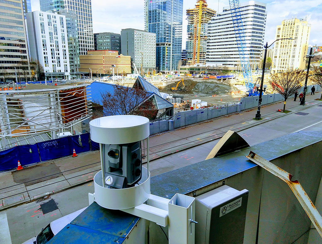
Automated Motorized Total Stations
1 Alliance designs, installs and operates advanced monitoring systems that provide clients with the essential information they require to enhance their decision-making process and site management. AMTS systems, built around high-precision robotic total stations, operate autonomously, providing frequent measurements and web-based reporting to provide alarms, plots and integration with data from standard geotechnical instrumentation.